
We’ve compiled a list of 7 autumn hiking destinations in the US and included trail guides and information on how to get around.
Hiking during any season is great, but hiking during an autumn season offers a host of spectacular views of the colors of nature. These autumn hiking destinations in the US are a selection of gems we’ve compiled just for you. Experience areas that are home to the crimson and copper colors of the best season of all.
For your next autumn hiking adventure, try venturing out to one of these iconic locations.
Acadia National Park – Maine
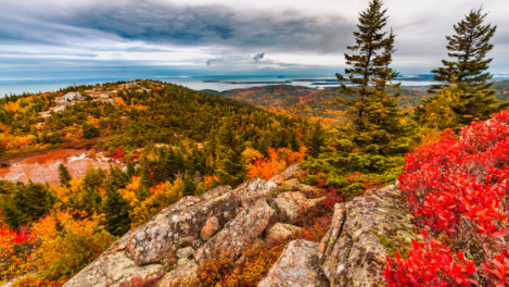
Located in Bar Harbor, Maine, Acadia National Park is one of the most scenic hiking destinations in the United States. This national park boasts 105 moderate hiking trails that begin with 0.9-mile trails to 27.1-mile trails.
The landscape of Acadia National Park has a vast difference in elevation; its 16-feet above sea level at its lowest and 1,525-feet above sea level at its highest point.
There are seven climbing locations in Acadia National Park in the autumn, which offer incredible climbing opportunities. Among these, Otter Cliff is arguably the most popular climbing spot in this national park with over 70 routes. Other climbing spots in Acadia National Park include:
- The Precipice
- South Bubble
- Great Head
- Eagle Crag
This national park is in the northeast, so expect some colder temperatures. It might be a good idea to pack some hand and feet warmers or even a portable campfire.
Maroon Bell – Aspen, Colorado

You don’t just have to go to Aspen, Colorado for Winter skiing. Autumn in Maroon Bell gives birth beautiful colors that inspire trail hiking. Maroon Bell is often considered the most photographed location in Colorado. Its iconic snow-striped mountains offer beautiful views of America’s Rocky Mountains.
If you’re looking for an adventurous Autumn hike in Maroon Bell, there are three main trails to choose from:
Maroon Lake Scenic Trail
This trail surrounds an active beaver pond and is an easy, 1.5-mile, round-trip hike from the parking area. At its highest point, the trail reaches an elevation of 9,700 feet (2957 m). Click here for printable, official information and regulations about Marron Lake Scenic Trail from the USDA.
Maroon Creek Trail
The Maroon Creek Trail will take hikers on a scenic route around alpine meadows, forests of Aspen trees and rocky slopes. This trail is a 3.2-mile hike that will feature possible sightings of wild animals, and it is a one-way trip. Hikers may see mule deer, bighorn sheep and porcupines.
Hikers can use this trail for horseback riding and it is considered a less crowded alternative for viewing the Maroon Valley, Maroon Bells and the Pyramid Peak. Check out the USDA’s printable information sheet for Maroon Creek Trail.
Crater Lake Trail
With Crater Lake as a centerpiece for this 3.6-mile round-trip trail, hikers will experience a steep ascent. This trail is rocky and prone to spontaneous thunderstorms and the temperature cools down the further up you travel. Recommended hiking seasons for the Crater Lake Trail are Summer and Fall.
Check out our essentials list of things to pack for semi-cold weather hiking; Aspen this time of year can get pretty crisp.
Appalachian National Scenic Trail – Pennsylvania
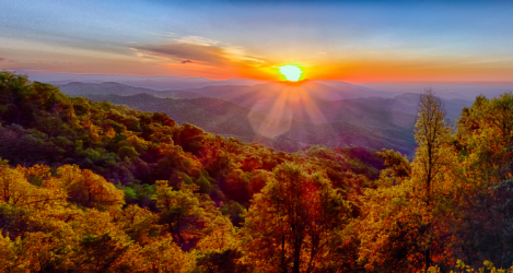
The longest hiking-only trail in the world, the Appalachian Trail is a must-do for avid hikers. But even if you can’t thru-hike the entire trail, which spans from Maine to Georgia, you can catch parts of it through any of the 14 states it runs through, including Pennsylvania.
The Appalachian National Scenic Trail spans 2,200 miles (3540 km), and 229 (368 km) miles of it are located in Pennsylvania from the Maryland border to the New Jersey line. Hikers can access the trail through Route 309, 33, and 115.
This trail will provide a once-in-a-lifetime experience of an iconic route through lively forests. While the trail will not always be full of thru-hikers, you can expect a level of comradery with other hikers you’ll pass by, here and there. Many businesses offer meals and lodging spots outside of the trail’s exit/entry points, and there is a network of mail drops available for hikers to forward themselves packages along the way to lessen the weight burden.
Sterling Pond Trail – Vermont
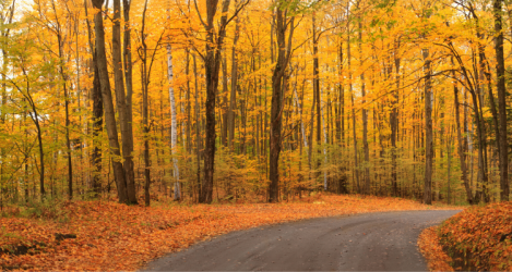
The Sterling Pond Trail in Vermont leads hikers on a 2.4-mile roundtrip hike up to the summit of Mount Sterling and to the highest trout pond in the state. There are some steep areas, and it begins with a rocky staircase up to the trailhead and proceeds into the treeline.
This trail offers views of Smuggler’s Notch ski resort, and this area is where to go for views of Mount Mansfield.
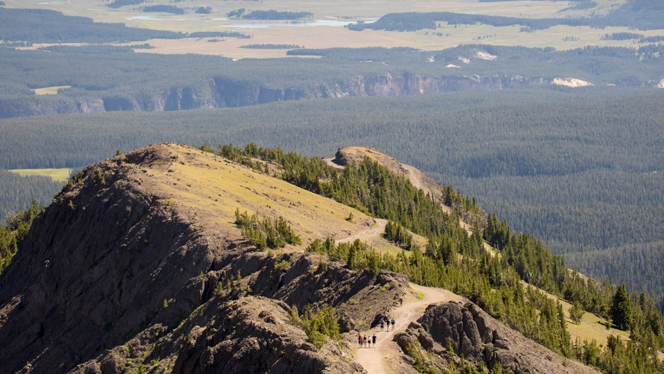
Yellowstone National Park, Canyon Area- Wyoming
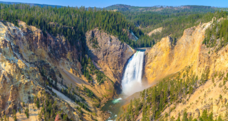
We all know Yellowstone National Park is a natural gift to humanity, and the area is too vast to cover in one small section. We’ll cover other portions of Yellowstone National Park is separate features in the future.
For now, let’s cover the great day hikes available in the canyon area of this +2 million acre preserve.
Cascade Lake Trail
The Cascade Lake Trail is a 4.4-mile (7-km) hiking route that takes about two to three hours to complete. It’s a roundtrip route that begins and ends at the same trailhead, which is located about 1-¼ miles (2 km) north of Canyon Junction on the Grand Loop Road. Pets are not allowed on this trail.
Chittenden Road – Mount Washburn Trail
Located in Canyon Village, the Chittenden Road Mount Washburn Trail takes around three to five hours to complete. It’s a 5.8-mile (9.3-km) hike that begins and ends at the same trailhead, which starts at the parking area on Chittenden Road, 10.3 miles (16.5 km) north of Canyon. This is the shortest, most direct route to the summit of Mount Washburn and it features and gradual incline.

Warnings: While this trail is open during the fall season, it is not recommended to travel this route in September or October, as grizzly bears frequent the area. But generally, August and November hikes are fine. This trail is also not recommended for persons with heart/respiratory conditions. No pets are allowed on this trail, and there is no access to water along this route. Thunderstorms may occur above the treeline.
Dunraven Pass – Mount Washburn Trail
Dunraven Pass – Mount Washburn Trail
The Dunraven Pass – Mount Washburn Trail is a three to six-hour hike starting from the trailhead at the parking lot at Dunraven Pass, 4.5 miles (7.2 km) north of Canyon Junction. Wildlife sightings of bighorn sheep are common, and wildflowers grow in abundance here. This trail will take you on a six-mile (9.6-km) roundtrip autumn hike.

Warnings: Try to avoid this trail in September and October, as grizzly bears frequent the area. This trail is also not recommended for persons with heart/respiratory conditions. No pets are allowed on this trail, and there is no access to water along this route. Thunderstorms may occur above the treeline.
Grebe Lake Trail
This trail runs along an old fire road in Yellowstone. Hikers will be taken through meadows and forest landscapes, some of which burned in 1988 – a historical sight. The Grebe Lake Trail is a 3-4-hour, 6.2-mile (9.9-km) hike that begins and ends at the same trailhead, 3-½ miles (5.6 km) west of Canyon Junction on the Norris–Canyon Road.
This trail does connect to the Howard Eaton Trail, so you can choose to extend your hike or just keep along the main trail and head to the trailhead.

Howard Eaton Trail
The Howard Eaton Trail is one that should be planned beforehand. First, this is a 10.7 mile (17.1 km), one-way trail. This is an adventure trail, and hikers can choose one of four lakeside destinations.
The Howard Eaton Trail passes by Cascade Lake, Grebe Lake, Wolf Lake and Ice Lake. It also passes through forests, meadows and marshland. The trailhead begins ¼-mile (0.4 km) west of Canyon Junction on the Norris–Canyon Road.

Warnings: This trail does not allow pets, it may be muddy and wet in places and, in the summer, there can be biting insects.
Mount Washburn Spur Trail
Heading back to a one-trailhead route, the Mount Washburn Spur Trail begins at the Glacier Boulder Pullout on the road to Inspiration Point. Hikers can catch views of Mount Washburn and the Washburn Hot Springs along this eight to 10-hour, 16.2-mile (25.9-km) trail.
While this trail begins and ends at the same trailhead, it can be started via another route. If you’re interested in either the Chittenden Road – Mount Washburn Trail or the Dunraven Pass – Mount Washburn Trail, after ascending Mount Washburn, you can catch Mount Washburn Spur Trail and end your hike on its trailhead at Glacier Boulder pullout. If doing this, you will want to make plans for a dropoff/pickup at either end.

Warnings: Beware of bears and lighting. Pets are not allowed and there is no water access along this route. Avoid this trail in September and October.
Observation Peak Trail
The Observation Peak Trail will take you along a 9.6-mile (15.4-km) route to a high mountain peak with awesome autumn views of the Yellowstone wilderness. Then, you’ll travel through open meadows and all the way to Cascade Lake.
This hike will take between five to 6 hours and begins at the trailhead located at the Cascade Lake trailhead 1-¼ miles (2 km) north of Canyon Junction on the Grand Loop Road.

Warnings: This trail does have a significant incline; it climbs to 1,400 feet in 2.6 miles through the forest, so it is not recommended for people with cardiac or respiratory conditions. This trail can be wet and snowy and times and there is no water past Cascade lake.
Ribbon Lake Trail
Ribbon Lake Trail beings 2.3 miles south of the Canyon Junction on the South Rim Drive at Uncle Tom’s Point parking area. There is a path that leads across South Rim Drive to the Clear Lake trailhead. At the Clear Lake junction, turn left. Continue on the trail following the junction signs until you reach Ribbon Lake.
Hikers can return via the same route, or they can choose to make an alternate loop by taking a right at the Lily Pad Lake Junction. After .03 mile (0.4 km,) you will reach another junction for Point Sublime and Artist Point. Head west towards Artist Point.
Continue to the Artist Point parking area. At the southwest end of the Artist Point parking area, connect with the paved South Rim trail. Follow the South Rim Trail along the canyon edge back to your car. This trail will take about 3-4 hours to complete and spans 5.8-miles (9.3-kilometers).

Warnings: Clear Lake is a hydrothermal area. Stay on the designated trail at all times. No pets are allowed on this trail.
Seven Mile Hole Trail
For the first 1-½ miles of the Seven Mile Hole Trail, you will walk near the canyon rim and have views of Silver Cord Cascade across the canyon. After another ½-mile, the trail will join the Washburn Spur Trail.
In ¾-mile, turn right onto the trail to Seven Mile Hole, which drops more than 1,000 feet in 2.3 miles. The trailhead is located at Glacial Boulder pullout on the road to Inspiration Point, and the entire hike will take about five to eight hours and spans 10-miles (16-kilometers).

Warnings: The trail passes both dormant and active hot springs. Stay on the trail. The only reliable water source on the trail is the Yellowstone River.
Denali National Park – Alaska

Denali National Park is home to Denali, one of the mountains on the Seven Summits list and the highest peak in North America. In autumn, Denali National Park can supply hikers with incredible scenic views of Wonder Lake and Reflection Pond.
Hiking in Denali National Park offers over 20 trails and paths around the site.
| Trail | Brief Description | Time | Distance |
|---|---|---|---|
| Bike Path | Travels right along the Denali Park Road, between the entrance and the visitor center. The surface is well-compacted gravel. 5% maximum grade, 10′ width. | 45 minutes one-way from the Denali Visitor Center | 1.7 miles, one-way |
| Horseshoe Lake Trail | A popular trail that descends to, and travels entirely around, a lake. The surface is five feet wide, with uneven soil, rocks and roots. It begins with a short, steep uphill to a bench overlooking the lake. The trail then descends 250′ steeply to the shore of the lake. The trail grade averages 5% with sections up to 20%. | 2 hrs. round-trip from its trailhead (+30 min. from DVC) | 2 miles, round-trip (+1 m. round-trip from DVC) |
| Jonesville Trail | A steep shortcut from Riley Creek Campground to the Canyon. It has a surface of compacted gravel. From west to east, it drops about 150 feet. | 10 min. one-way from either trailhead | 0.3 mile, one-way |
| McKinley Station Trail | Descend from the visitor center to Hines and Riley Creeks, and pass under the Alaska Railroad trestle. The trail is compacted gravel. It has an 8.5% grade maximum, dropping ~100 feet in the process via one long, gently sloping hill. The trail is 5′ wide. | 1 hr. one-way from the Denali Visitor Center | 1.6 miles, one-way |
| Meadow View Trail | A narrow, 30″-wide trail overlooking a meadow, forming a short connection between Rock Creek and Roadside Trails. The trail is relatively level but has a steep drop to one side. | 15 min. from either trailhead | 0.3 mile, one-way |
| Morino Trail | A short trail through spruce forest. Good for a quick walk while waiting on a bus or train. | 15 min. one-way from its trailhead | 0.2 mile, one-way |
| Mount Healy Overlook Trail | An increasingly steep hike out of the forest and into the alpine country, with potential views of Denali, if skies are clear. The trail surface is rough soil with rocks and roots. Eventually becomes very steep, maxing at a 25% grade. Generally 24″ wide. | 2 hrs. one-way from the Denali Visitor Center | 2.7 miles, one-way |
| Oxbow Loop Trail | Contours along the west bank of the Nenana River, offering views from above the river. The trail wanders in and out of spruce forest and drops down to the edge of the river. Trail provides walk-in access to a gravel bar on the Nenana River, which might be useful for rafters.
Note: The trailhead is located on the east side of Highway 3, about 7 miles south of the park entrance, near a bridge over the Nenana River. |
1-hour round-trip from its trail-head | 1.5 miles, round-trip |
| Parks Hwy Bike Trail | A paved path alongside Highway 3. | 30 min. one-way | 1.0 mile, one-way |
| Roadside Trail | Travels uphill from the visitor center to the sled dog kennels and park headquarters. Runs generally uphill from east to west, up to a 15% grade; generally 36″ wide. | 1 hr. one-way from the Denali Visitor Center | 1.8 miles, one-way |
| Rock Creek Trail | Occasionally steep trail through forest. Similar route to Roadside, but a bit longer and much quieter, as it’s farther from the road. Runs generally uphill from east to west, up to 15% grade; generally 30″ wide. | 1.5 hrs. one-way from the Denali Visitor Center | 2.4 miles, one-way |
| Spruce Forest Trail | A short trail through spruce forest. Good for a quick walk while waiting on a bus or train. 0% grade change, with a width of about 5 feet. | 20-minute loop | 0.2 mile, one-way |
| Taiga Trail | A short, forested trail mainly used to access Horseshoe Lake from the visitor center. The surface is gravel, with open steps across ditches. Grade is about 5% with sections up to 15%, 24″ wide. | 45 min. one-way from the Denali Visitor Center | 0.9 mile, one-way |
| Triple Lakes Trail | Denali’s longest trail, with bridges over two creeks and views of three lakes. Surface is a mix of compacted gravel, soils, rocks, roots, and sections of planks over marshy ground. Trail is up to 20% grade at times, generally 24″ wide. Note: The southern trailhead is located on the west side of Highway 3, about 7 miles south of the park entrance, near a bridge over the Nenana River. | 5 hours one-way from the Denali Visitor Center | 9.5 miles, one-way |
| Mountain Vista Trail | Located at Mountain Vista Rest Area, at Mile 13 of the Denali Park Road. Can be accessed by the free Savage River Shuttle and private vehicle, with ample parking available. The trail has a 5% maximum grade and is 6 feet wide. | 30-minutes, loop | 0.6 mile, round-trip |
| Savage Alpine | Connects Savage River and the Mountain Vista day-use areas. Parking available at either end. Use free Savage River Shuttle to return to your vehicle. Considered strenuous, the trail has steep sections up to 25% grade and is generally 24″ wide. | 3 hrs. one-way from Mountain Vista Trailhead | 4 miles, one-way |
| Savage River Loop | Located at the Savage River at Mile 15. Can be accessed by free Savage River Shuttle. On the western half of this loop, the first 1/4-mile of the trail is around 2 ft. wide and flat. Trail narrows and has more impediments like rocks and uneven surfaces. | 90-minute loop | 2 miles, round-trip |
| Tundra Loop | From the Eielson Visitor Center, at Mile 66 of the Denali Park Road, this short loop explores alpine tundra. Negligible grade change and generally two feet or wider at all times. | 15-minute loop | 0.3 mile, round-trip |
| Thorofare Ridge Trail | From the Eielson Visitor Center, this switchback trail climbs to a ridge for high, scenic views of Denali and a vast expanse of tundra beyond. | 1 hr. one-way from Eielson Visitor Center | 0.8 mile, one-way |
| Gorge Creek Trail | Descends 600 feet to the Gorge Creek and Thorofare River bars. Access to numerous off-trail day-hiking opportunities and backcountry camping units. A creek crossing may be required if you want to hike past the end of the trail. | 90 minutes round trip | 2 miles, round-trip |
| Table courtesy of NPS |
For climbing in Denali National Park, there’s really no better place to look than Mount Denali. Although, climbing on this mountain should be reserved for experienced high-altitude climbers. While beautiful, it is a dangerous mountain with many mountaineering disasters under its belt. Always plan ahead and stick to general mountain safety tips when going to the mountains.
Portland Japanese Garden – Oregon
The Portland Japanese Garden is considered by many to be the most beautiful place in the city. It’s not a hike per se, but missing it during the Autumn season would be a travesty. Instead, consider it to be like a place of quiet reflection where you can stroll the vistas of the season in a calming state of relaxation. Touring the garden is a physical activity, so you’ll still be out and about in nature.
If you’re a traveler, and you’re interested in national parks around the world, check out our article, “Must-See National Parks Across the World – Infographic“, for more great hiking destinations. Also, check out this recommended article below.
If you’re planning on bringing a metal detector with you to any of these locations, find out if you need a permit and what the regulations are. It may be prohibited in some places.
Recommended Article
![]() Now that you know where to go for spectacular, scenic autumn hiking views in the US, head over to Exploring Slovenia for beautiful colors of the fall above Bohinj: Pokljuka, Triglav Lakes and Vogel.
Now that you know where to go for spectacular, scenic autumn hiking views in the US, head over to Exploring Slovenia for beautiful colors of the fall above Bohinj: Pokljuka, Triglav Lakes and Vogel.
About Exploring Slovenia
Exploring Slovenia is an exciting hiking, climbing and skiing tour company in Slovenia. Exploring Slovenia offers unique travel experiences for small groups to take part in big adventures with local teams and experienced, certified mountain guides. Visit Exploring Slovenia today to learn about available tours and plan your adventure with quick, easy arrangements.

What do you mean by lodgings near the ANST entry and exits? I was thinking of doing a hike through just one state. An alternative to sleeping bags every night would be cool, but I don’t want to stay in a hotel. That defeats the purpose.
LikeLike
I was literally here to ask the same thing!
LikeLike
Jason, here’s a great article that goes over some Appalachian trail shelters and what they are like: https://sectionhiker.com/sleeping-in-an-appalachan-trail-shelter/
Alternatively, there are other private properties that run along or near the trail that have set up small shelters, shared spaces or camping cabins for hikers.
LikeLike